As the southeastern United States braces for Hurricane Dorian's impact, North Carolina is preparing as well.
The hurricane—a Category 4 storm with winds at nearly 150 mph, as of 11 a.m. Saturday—is likely to hit Florida's coast Monday evening or Tuesday morning. North Carolina issued a state of emergency Aug. 30. Although the state will not likely experience the full effects of Hurricane Dorian this weekend, Gov. Roy Cooper's order suspended certain transportation rules—such as weight requirements and maximum driving hours—to benefit farmers and boost relief efforts.
“Some farmers have let us know that they are taking action now to harvest and transfer crops to protect them from potential damage and they need these restrictions lifted,” Cooper said in a news release.
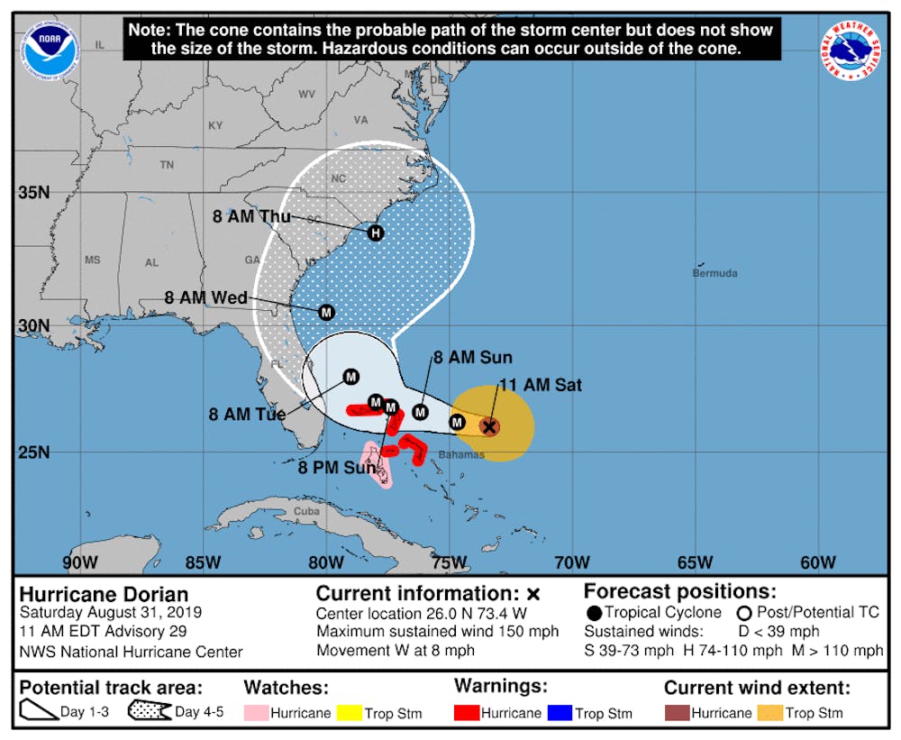
Sitting approximately 415 miles from West Palm Beach, Fla., as of 11 a.m. Saturday morning, Hurricane Dorian's anticipated course recently shifted to put North Carolina in the potential path.
Team members from Duke's Emergency Management System have been keeping an eye on the hurricane, Vice President for Administration Kyle Cavanaugh wrote in an email Saturday afternoon.
"We are now 5-7 days out from any potential impact but our teams have been in touch with our colleagues at the Marine Lab, and will continue to monitor the developments over the next few days," he wrote.
The latest projection by the National Oceanic and Atmospheric Administration foresees the storm battering eastern Florida before moving northward toward the Carolinas. However, forecasters are still uncertain about the picture of Dorian's path. There is "large uncertainty in the exact location and timing of this northward turn," according to a NOAA advisory.
"The risk of strong winds and dangerous storm surge is increasing along the coasts of Georgia, South Carolina and North Carolina during the middle of next week," the advisory states. "Residents in these areas should continue to monitor the progress of Dorian."
Raleigh has the potential to begin experiencing sustained winds of 40 mph beginning Tuesday morning and into Thursday morning, though the likelihood of such winds is low. The probability stands at less than 5% from Tuesday to Wednesday morning, and less than 20% from Wednesday to Thursday morning.
Other North Carolina cities closer to the Atlantic Ocean, such as Wilmington and Surf City, have around a 40% chance of experiencing 40 mph winds starting Wednesday morning.
Last year, North Carolina was hit by multiple hurricanes. Hurricane Florence, also a Category 4 storm, was projected to pass through Duke's campus before its path shifted and the hurricane skirted around central North Carolina. Classes were canceled from Wednesday evening Sept. 12 to Saturday Sept. 15 in anticipation of the storm.
Although the University escaped relatively unscathed, Florence's impact resulted in $24 billion in damage, according to a NOAA estimate released earlier in 2019. That number trails Hurricane Michael, another system that hit North Carolina but was downgraded to a tropical storm before reaching the state. Michael reportedly caused $25 billion in total damages across the Southeast.
Editor's note: This story was updated Saturday afternoon to include Cavanaugh's comments.
Get The Chronicle straight to your inbox
Signup for our weekly newsletter. Cancel at any time.